PG&E Desktop Review Incorporating Recent Inspection Data
Situation
 Pacific Gas & Electric (PG&E) is the largest electric utility within the state of California, encompassing approximately 2.5 million poles across their service territory. PG&E purchased O-Calc® Pro in 2014 as their standard pole loading software for over 700 distribution engineers. In the years following, PG&E implemented O-Calc Pro within their systems and processes. To further elaborate, O-Calc Pro has been integrated within their geographical information system (GIS), asset and work management systems, and other information based on internal construction standards. The integration of O-Calc Pro in these systems, in combination with stored data from other PG&E systems, resulted in a pole loading database that stores a virtual representation of the pole including information such as the conductors, equipment, and guying information.
There are approximately 700,000 poles within high fire threat regions. PG&E needed to understand the amount of pole loading utilization occurring on each of these poles, especially within the Tier 2 and Tier 3 high fire threat zones. To verify the pole loading information, PG&E needed to integrate recent data from inspections occurring in the past year approximately. These inspections included aerial and mobile LiDAR inspections as well as foot patrols to collect high resolution images.
Solution
PG&E engaged Osmose to make optimal use of the most up-to-date inspection data. First, Osmose integrated the LiDAR inspection data and high resolution digital images within the O-Calc Pro application and pole loading database. Secondly, Osmose technicians performed a desktop review of pole loading analysis on the poles located in the high fire threat zones.
Additionally, Osmose enhanced the O-Calc Pro software for PG&E so that the LiDAR and high-resolution imagery can be utilized directly within the O-Calc Pro interface. The LiDAR data and digital images are stored within cloud-based Azure databases to allow easy access for both PG&E and Osmose employees. Various LiDAR data collection vendors (PG&E is currently using three) can post this data to Amazon Web Services for both PG&E and Osmose to utilize.
 What Are Benefits of LiDAR?
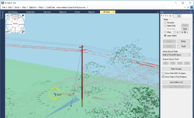
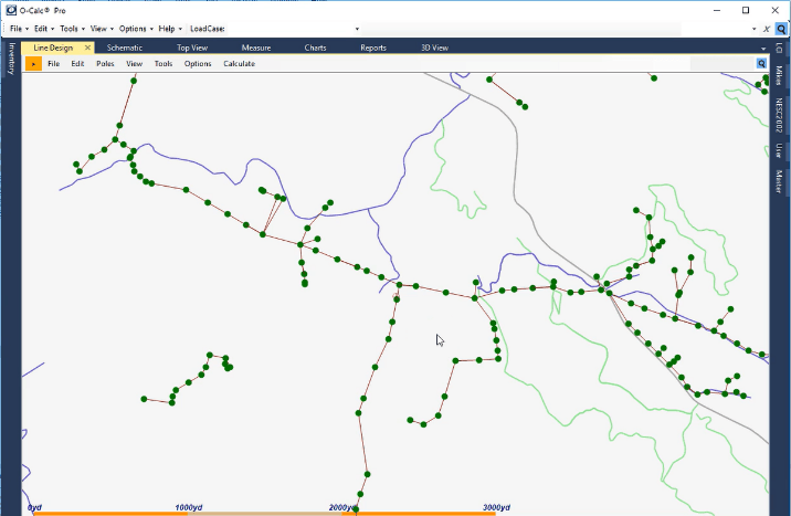
LiDAR data can be used within the PG&E GIS system to verify, and potentially correct, the pole’s latitude, longitude, and elevation. With the “ground truth location corrections” updated, Osmose, or PG&E, can correct the pole-to-pole span lengths and angles when necessary. These position corrections take place within the O-Calc Pro Line Design map interface. The LiDAR data can also be used to verify and correct the virtual representation of the pole loading model in the pole loading database. Corrections can include modifying attachment heights, locating missing or incorrect equipment attachments, leaning poles, and tension and sag adjustments of the conductors and cables. These corrections are made in the O-Calc Pro 3D View.
The data, maps, and imagery within the O-Calc Pro interface combined with the expertise of Osmose pole loading technicians provides a straightforward process needed to complete desktop reviews of each pole within the PG&E high fire threat zones. This process provides a solution to quickly identify overloaded poles and other risks. With the results from this process, PG&E can mitigate the issue with additional solutions such as upgrading wood pole capacity with the Osmo-ET Truss®.
For more information about O-Calc Pro, contact your local Osmose representative or email ocalc@osmose.com.
The information expressed in this article belongs solely to Osmose. PG&E is not a co-author and any reference to PG&E and a specific product, process, or service does not constitute or imply an endorsement from PG&E.
